EMERGENCY services have spent the morning preparing for an early afternoon wind change they fear may drive a major Sunshine Coast blaze into new areas of bushland.
Queensland Fire and Rescue Service spokesman Andrew Berkman said a lot of effort had gone into developing containment lines and dampening down ahead of the expected south-easterly change which was due about 12.30pm.
Mr Berkman said while there were still some flare-ups yesterday's blaze was well within containment lines, however there were concerns about the wind change driving the fire into unburned country in the Little Mountain area.
A fire was also burning in inaccessible country around Bells Creek.
Mr Berkman said 200 people evacuated yesterday had returned to their homes last night.
He said the evacuations of 150 people from a retirement village and 50 local residents was because of fears that the dense smoke would cause respiratory problems.
The fire was driven yesterday by strong winds as wild weather swept the country.
Firefighters battled howling 35km/h winds to contain the blaze, which flared near Bells Creek in the early morning.
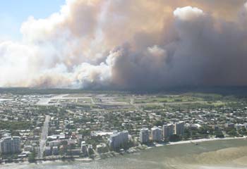
By lunchtime, the fire had cut a swathe through the suburbs of Pelican Waters, Little Mountain and Caloundra West � choking the skyline with a heavy smoke cloud visible from Noosa at the northern end of the Sunshine Coast.
A school, three nursing homes and the city's airport were evacuated as a precaution from the fire, which is expected to continue to burn throughout today.
Further west, a bushfire burned through the Tarong State Forest near Nanango, destroying 80ha of state forest to about 5km from the Tarong power station by late yesterday.
The fires, however, were only one story in a day of harsh extremes � with thermometers hitting 40deg in the far north while snow-like sleet fell in the south.
The snow, which fell on the Granite Belt district near the Queensland-NSW border, was described by forecasters as a once in 50 years phenomenon for November.
The last time snow or sleet was reported there was in 1941.
Bureau of Meteorology senior forecaster Jeff Callaghan said the "very unusual" weather had been caused by a cold front which had travelled from Victoria.
It was the same front which caused violent hail and thunderstorms in Queensland's southeast and snow in Victoria and Tasmania on Wednesday.
"The storms formed ahead of the cold front and now the cold front's coming through with very, very cold air," Mr Callaghan said.
"It happens, but not very frequently. The atmosphere keeps on repeating itself for extreme events every 50 or 100 years or so."
While Applethorpe, in the Granite Belt, recorded the coldest temperature statewide at only 11C, Coen, Kowanyama and Musgrave, all in the far north, recorded the warmest at 40C.
Sydney, meanwhile, recorded its lowest minimum temperature in November for more than 100 years � with the mercury dropping as low as 8C.
1 comment:
What kind of crazy weather are we having , ice bergs off NZ. No climate change? yeah right
Post a Comment